***To all of my readers: I hope you and your families had a very blessed Easter Sunday and that you have a holy Easter Season!***
Note from the Author: Copy/paste GPS Coordinates listed below into Google Maps to see or travel to each location.
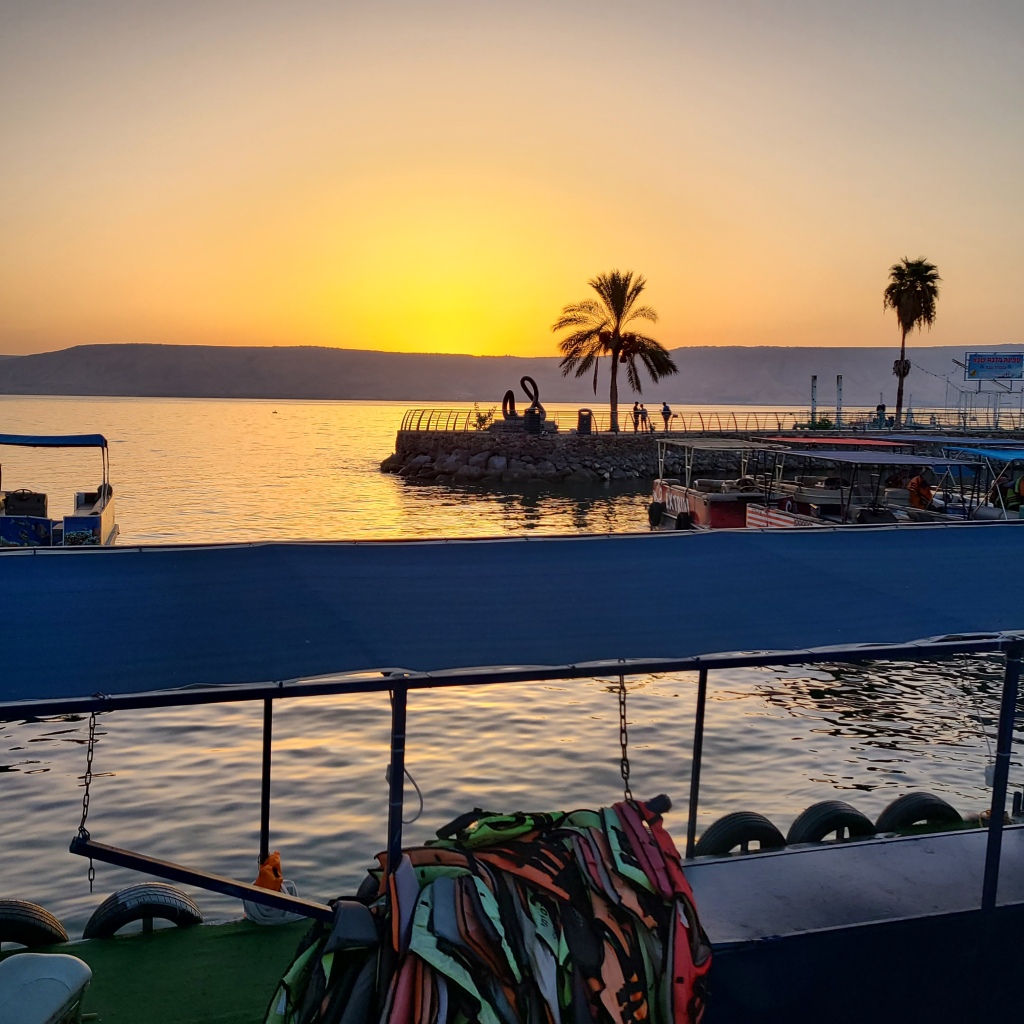
The day before and the day prior had been exhausting, but I wanted to squeeze every minute I could out of this incredible opportunity to explore the Holy Land and trace the footsteps of our Lord. I woke up at 0600 on Day 3 and hurriedly got ready for the day. It was time for me to travel back to the Stone of the Hemorrhaging Woman to finish restoring it. When I exited my hotel in Tiberias, I noticed it was still before sunrise and I decided to run down to the boardwalk along the Sea of Galilee’s shore to take in the sea. The view of the sun rising in the east made one of the most beautiful sights I’ve ever seen. It was a cool and beautiful morning without a cloud in the sky, and so peaceful and quiet compared to the night before. After snapping a few pictures, I hopped into my rental car and drove the 20 minutes or so to my special Holy Site.

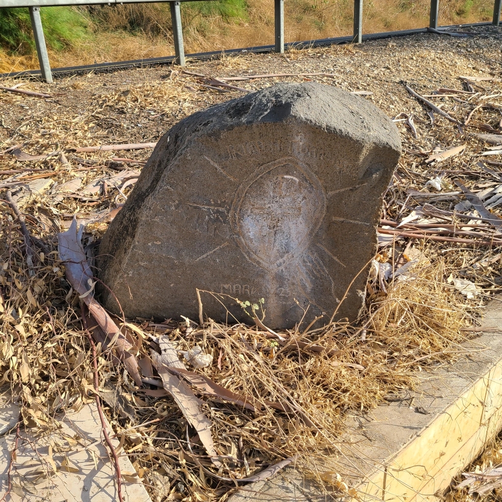
When I arrived, I parked, broke out my supplies, and examined the stone. My cleaning from the day before appeared to have done some good, and the stone was also now dry. I said a quick prayer asking St. Luke (patron of painters) to pray for me so I wouldn’t mess this up (I have minimal art experience), and began highlighting the carve marks in the stone with the Sunburst Yellow enamel paint I brought with me. It took some time and it was careful work ensuring the bright yellow paint didn’t accidentally drip where it shouldn’t have or gone outside the boundaries of the carving, but after about an hour I completed the job! I fought back the urge to go back and retouch parts up, concerned that, in so doing, I might go too far. To work off my nervous energy and the rush I felt completing a task I had longed to do for years, I began to pick up all of the litter in the area to make the place more presentable–this was the location of one of our Lord’s great signs, and it should be honored and respected out of love for Him. In the end, I was pleased with my work and hoped it brought glory to God and did honor to the memory of the woman who was healed near here because of her faith! The “Petra Hemorhoissae”…”Stone of the Hemorrhaging Woman.” (GPS Coordinates: 32°52’32.36″N, 35°33’40.59″E)


After tidying the area up, I got out my Synopsis of the Gospels and read each Gospel’s account of this healing of Jesus. The faith of the Hemorrhaging Woman truly was astounding–not to mention her audacity! According to Eusebius of Caesarea Maritima, an ancient Church historian who lived in the A.D. 300s, there exists a tradition that the woman was actually a gentile and not a Jew. A woman who not only had a flow of blood, but was also a gentile (!) who decided to sneakily touch a Jewish man in the First Century could have been a cause for great offense to Jesus and the Jewish Community. Anyone who touched her since she had a flow of blood would have been ritually “unclean.” Looking at this miracle through this lens, one can perhaps see why, in Mark and Luke’s Gospels, the woman “trembled with fear” when she had been found out! Jesus, on the other hand, is not made unclean by her–as He cannot be unclean because He is God–but paradoxically and mercifully, *He* makes her clean instead!

After finishing my time at this special place and saying a prayer to our Lord asking that my “artwork” would bear Him much fruit, I hopped in my car to go find and visit more little-known sites around Galilee that I had not been to before. It was after 9AM and I was running out of daylight to see all the places I needed to see. My next stop was the ancient mound of Tel Hadar. Ancient tradition holds that it was near this mound where Jesus fed the 4,000 Gentiles with 7 loaves and some small fish. There is a beautiful monument here commemorating this miracle (GPS Coordinates: 32°51’3.00″N, 35°38’57.87″E). One of the stones reads “Here Gentiles gave glory to the God of Israel. Matt. 15:32”


When listening to this story, it is easy to overlook the significance of what’s at play here. Jesus says several times in the Gospels that the focus of His mission is preaching to the Jewish people, not the Gentiles. However, as Jesus’s Ministry progresses, He begins to engage the Gentiles more. Unlike the Feeding of the 5,000 which occurred on the west shore of the Sea of Galilee which was Jewish territory, Jesus accomplished the Feeding of the 4,000 along the eastern shore of the Sea of Galilee which was Gentile territory. The fact that, as St. Matthew records, “the *Gentiles* gave glory to the God of Israel” is a major event that signals the coming of the Messianic Age as prophesied by Isaiah (who lived 700 years before Christ).

After visiting this Holy Place (around which was a campground filled with hundreds of Israelis (already at 10AM) enjoying the beautiful outdoors by the Sea–it gave me a glimpse of what the Feeding there couple have looked like!), I drove to the site known as El Araj near the northern shore of the Sea of Galilee. The site has been known to contain remains of ancient structures for many years, but only in 2019 did archaeologists from Kinneret College in Israel and Nyack College, NY excavate the area and by chance discover the remains of a Byzantine Church! This church and its location align most closely to ancient pilgrim descriptions of a church known as the “Church of the Apostles.” Tradition has it this church was built over the childhood home of Sts. Peter and Andrew who were both originally from the town of Bethsaida. Bethsaida was also a town where Jesus did some of His great works during His ministry. There is a competing location for Bethsaida of the Gospels which is known as Bethsaida Julius which is north of El Araj. Although this city could have been connected somewhat to the settlement at El Araj, I believe that the location of El Araj is the best candidate for the location of the Bethsaida in the Gospels. In fact, the discovery of a new Byzantine floor mosaic in the Summer of 2022 (shortly before my visit) further strengthens the case that the church is connected to the Apostles. According to the El Araj Excavation Project website, the mosaic dedicatory medallion (see photo below) “references a donor, ‘Constantine, the servant of Christ,’ and continues with a petition for intercession by St. Peter, ‘chief and commander of the heavenly apostles.’” (See the Season 6 Excavation Press Release: https://www.elarajexcavations.com/)

It took a little time for me to locate the site of the ruins of the Church of the Apostles. The way is not marked by road signs, is a mile or two off the main highway around the Sea of Galilee, and can only be accessed via dirt roads. However, when I parked near the site, I was surprised to see many cars there. However, they were not there to see the home of the Apostles, but were there for recreation time. There were several families camping near the ruins, and one family was inflating a paddleboard. I weaved my way through the campsites to an open area with excavated ruins. I was pretty confident I had found the location of the church, however, the site looked different than the pictures I had seen in online news articles and in Biblical Archaeology Review magazine. I surmised the site probably looked different due to some of the pictures I had previously seen of the site being older– i.e. when the site was less excavated. After searching on my smartphone for more pictures of the excavation site and comparing the backgrounds in those pictures to more permanent features I could then see in-person (e.g. a house near the site), I finally verified that I was at the right place: standing on the ruins of the Church of the Apostles, above the site of Sts. Peter and Andrew’s childhood home, in Biblical Bethsaida! (GPS Coordinates: 32°53’34.19″N, 35°37’10.60″E) It was an incredible experience and feeling to be standing where St. Peter, our first Pope, and where his brother St. Andrew, the “First Called” of the Apostles (see John 1:40), learned to first walk and speak. It was also near here where the Lord healed a blind man (See Mark 8:22) and did other “great works.” (Matthew 11:21)

The excavations at the site had revealed a tangled web of wall foundations from several buildings. At this site there were remains of a Roman bathhouse, The Byzantine Church of the Apostles, and a Crusader Era sugar processing facility–apparently the church had been in a ruinous state and people during the 1100s-1200s just built over top of it!
One is able to identify the remains of the Church of the Apostles by identifying the foundation walls of its apse (the curved building wall at the front of churches behind the altar) and following the rectangular foundation walls radiating out from either side. I was able to find the apse (shown in the picture below, with other walls built over it and through it). The different segments of wall running into the apse are from later structures (likely the Crusader structure) built over the remains of the church. Approximately in the middle of the photo below would have been where the Church of the Apostles’s altar would have stood where the Eucharist would have been celebrated.

Below is a view of the wall foundation on the opposite side of the apse, looking toward the apse (front of the church). The entrance to the church would probably have been around this location. This church and the town of Bethsaida (a name which in English means “House of Fish”) are near the northern shore of the Sea of Galilee and where the Jordan River empties into the sea. Over the centuries, with the ebbs and flows of civilizations, conquests, and natural disasters, the town here was abandoned, destroyed, and covered up with silt and mud from the Jordan River. As I stood there looking at the remains of the church, I contemplated what the church would have been like when it was still being used. What were its parishioners like? What did a Mass here look and sound like? Thinking further back, what must have this fishing town looked like when little Peter and Andrew ran through its streets playing, or when learning the occupation of fishing–probably from their father John. Was the Roman bathhouse discovered near their home a place the Apostles would visit from time to time?

After saying some prayers, I headed back onto the highway around the Sea of Galilee and headed west. Along the way, I stopped at a bend in the highway at the western ridge of the Jordan River Valley. For several reasons, there is a decent probability that this place was or was near the tax station of the Apostle St. Matthew. According to the account of an ancient pilgrim named Egeria, a nun from Spain who visited the Holy Land in the A.D. 380s, it was along the road running up the western shore of the Sea of Galilee that St. Matthew had his tax booth. Additionally, at the time of Christ, the northern Jordan River would have served as the legal border between two separate “states” within Roman Palestine. It is likely there would have been a customs place along the Jordan River so taxes could be collected for goods transiting the border. The place I was at was both along the “Via Maris” seaside road and was at the western top of the Jordan River Bank. It was a beautiful view (see photo below looking east towards where the Jordan River empties into the Sea of Galilee, near El Araj/Bethsaida) and amazing to think that Christ’s calling of St. Matthew may have been near here (GPS Coordinates: 32°53’49.73″N, 35°36’31.56″E), or possibly along this road on the opposite side of the river before it bisected into a westward branch towards Chorazin and a southwest-ward branch towards Capernaum (GPS Coordinates: 32°54’15.56″N, 35°37’6.10″E). St. Matthew was the patron of my parish growing up, so this was a special place for me.

From here, I drove to Capernaum, Jesus’s home during His ministry. Capernaum was a fishing town along the seaside road used by traders from Syria and Asia Minor traveling to Jerusalem and Egypt. Jesus would be able to engage with many people using this town as a base of operations. Today, the site of ancient Capernaum is actually divided into two parts: a side maintained by the Roman Catholic Church and a side maintained by the Greek Orthodox Church. Unfortunately, only the Roman Catholic side has been thoroughly excavated. I had visited the Roman Catholic side before, and this time, I wanted to do some exploring on the Greek Orthodox side. On the Greek Orthodox side, there is an exquisite church with iconography on its walls and ceilings of what seems like nearly every event in the Gospels! (GPS Coordinates: 32°52’52.19″N, 35°34’37.78″E) It was incredible! (see photos below)


After seeing the Greek Orthodox Church of Capernaum, I explored the area of Greek Orthodox Capernaum west of its church and closest to the Roman Catholic area of Capernaum. Excavations were conducted in this area by Dr. Vassilios Tzaferis, Dr. John C. H. Laughlin, and a team of other archaeologists from 1978 to 1982, and revealed the remains of a Second to Third Century A.D. Roman bathhouse (see photo below) (GPS Coordinates: 32°52’50.04″N, 35°34’34.41″E).

According to an article by Dr. Laughlin in the September/October 1993 issue of Biblical Archaeology Review, these remains are similar in structure to a First Century Roman bath used by a garrison of Roman soldiers at Ein Gedi, Israel on the west coast of the Dead Sea. Even more intriguingly, Dr. Laughlin mentions: “Beneath the bathhouse at Capernaum were earlier remains belonging to the first century A.D. (our stratum IX). Since we did not want to destroy the later building on top, the full plan of this earlier structure is still unknown. In general, however, the outline of the lower building is similar to the bathhouse above it. If this first-century building was also a bathhouse, then this may confirm the existence of the Roman centurion and garrison at Capernaum referred to in the Gospels.” It is, therefore, possible this may have been the site or approximate area where the Roman Centurion of Capernaum mentioned in Matthew 8: 5-13 and Luke 7: 1-10 lived. He is the man mentioned in the Gospels who had graciously built Capernaum’s Synagogue and had humbly asked for Jesus to heal his servant. This Roman military leader’s words “Lord, I am not worthy that you should enter under my roof…” are recited at every Roman Catholic Mass before Catholics receive communion around the world each day. The example of this man’s humility reverberates through history, and here I was, potentially standing near where he and his soldiers had lived in Capernaum. If the bath was somehow attached to his house, I could have been standing under where *his* roof once was!


I stood inside the doorway of one of the western-most rooms of the bath complex, nearest to St. Peter’s House on the Roman Catholic side where Jesus lived during His ministry (see photo below of the remains of the 2nd-3rd Century doorway), and I imagined the Centurion returning home–maybe through a 1st Century doorway that once stood close to here– and receiving the joyous news that his servant had been miraculously made well at the words of the Lord. Incredible…

After reading the Gospel accounts of the healing of the centurion’s servant in this place, I left this site and drove around to visit the Roman Catholic side of Capernaum. I had visited this place a couple times before, and it is a very amazing place. The front of the complex had a new sign, though that was not there when I had visited 10 years ago. The church had a name listed which I had not heard of before, but what is perhaps the best name that could be chosen for a church standing in Capernaum: “The Church of the Promise of the Eucharist.” For, it was in the Synagogue in Capernaum where Jesus first spoke of the Eucharist to his disciples. In Jesus’s Bread of Life Discourse (John 6: 22-71), Jesus directly communicates the critical role of the Eucharist in the lives of those who wish to follow Him. His listeners’ shocked reaction to Him (i.e. not the same reaction when He says “I am the vine” or “I am the gate” elsewhere in scripture), and His continual doubling-down on His “hard saying,” makes it clear He is not speaking figuratively. He *is* the “Bread of Life” –“For my flesh is food indeed, and my blood is drink indeed. He who eats my flesh and drinks my blood abides in me, and I in him.” This episode in scripture–which took place during the Jewish Passover (ref. John 6:4) in Spring A.D. 32–is inextricably linked to the accounts of the institution of the Eucharist, which took place at the Last Supper during the Passover the following year in A.D. 33. The Church has celebrated the Eucharist continually ever since, at the Master’s command, for over 2,000 years.

As I entered the Roman Catholic side of Capernaum, I saw a beautiful sculpture of Jesus that had been added since I last visited in 2012. The sculpture was called “Homeless Jesus.” It imagines Jesus (with nail marks in his feet) as a modern homeless person attempting to keep warm on a city bench. Although Capernaum was Jesus’s “home base” for His mission, He was continually on the move, sleeping wherever He could (ref. “Birds of the air have nests, foxes have dens, but the Son of Man has nowhere to lay His head.”). It was a powerful image: Jesus continues to be present to us in the poor and homeless we encounter in modern times–we are challenged to take action and help.

After setting foot into this other side of ancient Capernaum, I first walked to the Sea of Galilee coastline and worked to imagine this very shore as it was in the time of Christ: filled with fishing and transport ships. I visualized Sts. Peter and Andrew coming back home from fishing right here where it actually happened. I can imagine Jesus getting into boats here to set out to bring the Good News to all the towns and cities in Galilee. The water was a glassy turquoise, and the waves gently lapped on the rocky shore.


With the view being beautiful and the weather being so clear, I took out my binoculars to look around. Across the sea, I could see the area of Kursi. It was here according to ancient tradition and archaeological discoveries that Jesus met the naked demoniacs, healed them, and drove the demons into the 2,000 swine on the hillside. In Byzantine times, a chapel was built into the hillside’s cliff nearest the sea to commemorate the miracle (GPS Coordinates: 32°49’28.70″N, 35°39’4.14″E), and a monastery was constructed on the plain below the cliff/hillside (GPS Coordinates: 32°49’32.89″N, 35°39’2.28″E). The photo below, taken through my binoculars, shows the cliff in the bottom center, closest to the large grove of green trees. This view is what Jesus would have seen as He sailed across the sea to that place.

After taking in the shoreline, I then walked to the site of St. Peter’s home in Capernaum (GPS Coordinates: 32°52’49.87″N, 35°34’31.54″E). The modern Church of the Promise of the Eucharist was built over the remains of the Byzantine Memorial Church of St. Peter, both of which cover the remains of a 1st Century home and are centered over the home’s main room. This house is referenced in the Gospels and is where our Lord stayed during His Galilean ministry.
The modern Church is impressively suspended immediately over the center of the ruins where the main room of St. Peter’s House was located. (see photo below)


Up the main north-south road through Capernaum from St. Peter’s House is the Synagogue of Capernaum (GPS Coordinates: 32°52’51.49″N, 35°34’31.40″E). It was in this synagogue where Jesus drove out a demon at the beginning of His ministry before walking to St. Peter’s House to heal St. Peter’s mother-in-law. As you can see from the photo below, Peter’s House (at the far right of the photo) was very close to the synagogue site (where the white ruins stand on the left side of the photo). It was also in this synagogue where, according to St. John’s Gospel, Jesus preached the Bread of Life Discourse, introducing His followers to His teachings about the Eucharist.

The impressive synagogue currently standing, known as the “White Synagogue,” was built by Jews in the 300s over the ruins of the Synagogue where Jesus preached–the Synagogue built by the Centurion.

One can still see the foundations of one of the walls of Jesus’s Synagogue underneath the white marble of the current synagogue (see photo below).

After saying some prayers in Capernaum, I drove two miles southwest towards the area of Tabgha, known in Greek as “Heptapegon” or in English “Seven Springs.” It is known by this name because seven natural springs of water once gushed forth and watered this area. There are many ancient traditions locating several major events from Jesus’s Ministry in this relatively small area. The locations of two of these events, commemorated here by modern churches built over the sites of ancient churches, are: 1) the place where Jesus fed the 5,000 people, and 2) the place where the resurrected Jesus appeared to His Apostles and charged St. Peter to lead the Church and “feed His sheep.” Ancient pilgrim accounts and archaeology identify Tabgha with the locations of these events. Furthermore, St. John’s remark in his Gospel that the place of the Feeding of the 5,000 had “much grass” coincides with the fact that several natural springs probably watered this area at the time. Additionally, the resurrected Lord directing St. Peter to “feed His sheep” in the same place where Jesus a year before had blessed and broken the five loaves and given them to His disciples to feed the crowd, is a beautiful parallel. It adds additional context and meaning to Christ’s words–a great example of how the Holy Land serves as a “Fifth Gospel” to provide us greater understanding of Christ and what He did for the Church and for all humanity.
The pilgrim nun Egeria in the A.D. 380s speaks to us about another important site adjacent to Tabgha. Unfortunately, complete parts of Egeria’s pilgrimage account have not survived the ravages of time, and one of the sections that was lost is the section of her account describing the holy sites in Galilee. However, luckily for us, other ancient authors had access to her full manuscript and wrote down some excerpts of the missing sections. A deacon named Peter, a monk from Monte Cassino in Italy, wrote a book on the holy places using Egeria’s complete account as one of his sources. In his work, he utilizes Egeria’s pilgrimage account when he states “Near [Tabgha] on a mountain is the cave to which the Savior climbed and spoke the Beatitudes.” Furthermore, Valerius, a hermit from Spain who lived in the Seventh Century, wrote a letter about Egeria to help train monks. In this letter, he says Egeria visited a mountain called Eremus on which Jesus taught the disciples the Beatitudes.
That the mountain where Jesus preached the Beatitudes was known as “Eremus” is revealing. This Latin name in English means “lonely,” as in “lonely place.” It is probable this was the place Jesus retreated to pray after the Feeding of the 5,000 and possibly at other times for private prayer throughout His ministry. This mountain is a short 2-mile walk from Jesus’s home in Capernaum and was in a deserted area at the time. The Cave of the Beatitudes, found in the side of the mountain where Jesus preached the Sermon on the Mount–some of the most consequential words in human history–can still be seen today (GPS Coordinates: 32°52’24.32″N, 35°33’7.69″E). Many people visit the Church of the Beatitudes uphill from this location, but there has only been a church at that location since the 1920s and it does not mark the actual location where Jesus preached His sermon.
I parked across the street from the Mount of the Beatitudes and its cave and could see both. The place where the cave is on the mountain is not very high up from the roadway that would have led around the sea since ancient times. However, the mountain continues to slope upwards and get higher and higher up from where the cave was. It was of interest to me that, although He was God, chose not to preach the Beatitudes (i.e. the *new* Law of Moses) at the top of the high mountain, away from the people and the road system they used to get around. In this case, He didn’t also preach on the road itself (although He would also, of course, preach on level ground as in the Sermon on the Plain in St. Luke’s Gospel). Jesus preached the Beatitudes at a place where He could be near the people, but also in an elevated position. This is an amazing allegory, which is a spiritual fruit of the ancient tradition associated with this place. Everything the Lord did (and does) is for a reason, and I think this could have been one of the reasons why Jesus chose the place that He did to introduce the definitive Law, not just for the Jewish people, but for the whole human race. The place I was now standing (in the photo below), beside the highway and below Mount Eremus and its cave would have been the area where many people would have stood to hear Jesus preach the Beatitudes. Fr. Bargil Pixner, a great Holy Land researcher from the 20th Century, furthermore noted this mount is also very rocky and would likely have not been used by ancient farmers–this may have been one of the reasons Jesus chose this place: to show farmers charity by helping ensure the crowds would not disturb their crops and land.

Walking up the mount to the traditional location–which is not well-known to modern pilgrims who often visit the beautiful Catholic Church at the very top of the mountain, much removed from the cave–was invigorating. When the cave finally came into view, it was an incredible sight. St. Matthew says in his Gospel that Jesus sat down (the posture for someone teaching in the time of Christ) and then taught the people. Jesus could have sat in several possible locations here: on the ground in front of the cave, on the terrace above the cave, or a large black boulder on top of that spur of the mountain (covered by some grass towards the top right of the photo below).

I continued forward and went into the cave and sat down. One of the interesting physical features of this cave was the impressive, strong tree growing out of it and extending–near horizontally!–out of the cave (see photo below). I believe this is yet another instance of God utilizing physical matter at holy places to reveal deeper spiritual truths. The tree is an allegory of Christ’s word exploding out from this very place into the world–robust, strong, and overcoming adversity to spread out into the world.
The view of much of the Sea of Galilee and the surrounding area from the cave was breathtaking. It likely would have been from this location Jesus would have seen in the light of the Passover (potentially full) moon in A.D. 32, the Apostles struggling to sail in the early morning before sunrise, and chose to go out to them walking on the water!

After reading Matthew’s account of the beginning of the Sermon on the Mount, I continued to walk up the mountain’s rocky trail to another monument (seen in the center of the photo below) commemorating one or perhaps several events from the New Testament.

Further up Eremus is another monument which marks a possible location for the resurrected Lord’s Great Commission of the 11 remaining Apostles to go out into the world and make disciples of all the nations (see Matthew 28:16) (GPS Coordinates: 32°52’24.61″N, 35°33’5.65″E). Additionally, it is also thought this may have been the place of Jesus’s post-resurrection appearance to 500 disciples at once, according to St. Paul in his First Letter to the Corinthians (1 Corinthians 15:6). This seems fitting as the core of Jesus’s followers were from Galilee, Jesus appears to have had a special affinity for Eremus in particular (it served as the *new* Mount Sinai where, like the Israelites of old, mankind encountered God), and there was plenty of room for many people. The incredible view of the monument with all the world behind it made me reflect on what the disciples must have thought standing here listening to the Lord. Being at this place would have served as an impressive visual of the vastness of the world they were about to go into and conquer through the Lord’s grace.

The inscription on the stone shows a cross in the center representing Jesus, 11 lines surrounding it from the top representing the remaining Apostles who Jesus appeared to, and five Roman numeral 100s (“C’s”) surrounding it from the bottom representing the five hundred disciples who Jesus appeared to as well.

From Mount Eremus, you could also see the Church of the Multiplication of the Loaves and Fishes (below center with the darker brown roof) (GPS Coordinates: 32°52’24.31″N, 35°32’58.93″E) built over the place where Jesus gave thanks and distributed the loaves and fishes to the Apostles to set before the crowd. It was incredible to have a view of the whole area where the miracle of the feeding of the 5,000 took place, and imagining the area filled with people all eating and marveling at the mighty work of our Lord.

After this last stop, it was time for me to leave the Sea of Galilee and start making my way towards Jerusalem! It had been an absolutely incredible experience tracing the Lord’s footsteps in this holy region that, in my opinion, also happens to be the most beautiful place I have ever seen in all my travels.
American author Mark Twain, who traveled in the Holy Land in 1867, captures the meaning of Galilee and the amazing paradox of God’s love–the creator of the universe humbling Himself by sharing in our humanity–in the best way:
“In the starlight, Galilee has no boundaries but the broad compass of the heavens, and is a theatre meet for great events; meet for the birth of a religion able to save a world; and meet for the stately Figure appointed to stand upon its stage and proclaim its high decrees.
But in the sunlight, one says: Is it for the deeds which were done and the words which were spoken in this little acre of rocks and sand eighteen centuries gone, that the bells are ringing to-day in the remote islands of the sea and far and wide over continents that clasp the circumference of the huge globe?”
-Mark Twain, The Innocents Abroad
On my approximately 2-hour drive south to Jerusalem, I stopped at another mountain mentioned by the ancient pilgrim Egeria in her pilgrimage account: Mount Hermon, known today as Givat HaMoreh in Hebrew or Jebel Ed-Dahi in Arabic (i.e. not to be confused with the larger mountain of the same name northeast of the Sea of Galilee. Sometimes Givat HaMoreh/Jebel Ed-Dahi is also known as “Little Hermon” to distinguish it from the larger mountain.)
Egeria has this to say about the mountain: “Mount Hermon is very lofty, and from it there is a view over the whole of Galilee, unequalled for beauty, since the whole vast plain is vineyards and olive-groves. The field is there in which the Lord ate with His disciples, and you can still see the stone on which He rested His arm. Not far from this mountain is a spring which the Savior blessed and it does good to sick people of all kinds.”
Amazingly, there is no account in the Gospels of Jesus blessing a spring and no other written evidence of Him visiting this mountain. According to John Wilkinson’s comments in his superb translation of Egeria’s pilgrimage, he thinks the spring may have been a sulfurous spring on this mountain known as “Bir es Sheik.” It took some time and careful research for me to find the location of this spring, but I was finally able to locate it (see photo below) (GPS Coordinates: 32°37’8.95″N, 35°21’6.99″E). If you look at this location on Google Maps, it actually identifies the spring in Hebrew as a “volcanic crater” which would line up with Wilkinson’s assertion that the spring was sulfurous. Sulfurous springs sometimes have curative properties for individuals who bathe in them.

The spring was dry when I saw it, but I have a photo of the spring taken by some friends with the plant growth in the middle a brilliant green (see below)–this could be because the wet season had made the plants healthy and green, or the spring could still be active to some degree.

There was also an open area nearby that could have been the field Egeria spoke of. Either way, I meditated on how although the Lord may have stood here and blessed this spring. But, despite this, it is not a major pilgrimage destination, nor has it been for about 1,500 years. It made me wonder how many other locations there must be where the Lord did great signs that have not come down to us via the Gospels or other sacred tradition. We do know that Jesus was active in the area around Mount Hermon since the town of Nain, where Jesus brought the widow’s son back to life, is at the foot of this mountain–only about .75 miles to the north-northwest from the spring as the crow flies. So, Jesus enjoying the beautiful view from Mount Hermon and relaxing with His disciples, and also blessing a spring while there seems definitely plausible. As I stood there, I could only imagine the circumstances of Jesus’s presence there and what this episode from His ministry might have been like. While I was there, I read Egeria’s account, said some prayers, and began my journey down the mountain and on the road to the Holy City of Jerusalem.
Stay tuned for my post next week as I travel up to Jerusalem and explore the Chruch of the Holy Sepulcher, the site of the Upper Room, the Pool of Siloam, the historical Way of the Cross, and the nearby town of Bethany–home of the Lord’s friends Mary, Martha, and Lazarus. Thanks for reading, and see you next week!
Also, if you enjoyed, this post, check out my one-of-a-kind book, The Second Person of the Trinity in Time and Space: What is Known Historically About Jesus and the Holy Sites of the New Testament, sold on Amazon.com! (click below)
.wordads-ad-wrapper {display:none;font: normal 11px Arial, sans-serif;letter-spacing: 1px;text-decoration: none;width: 100%;margin: 25px auto;padding: 0;}.wordads-ad-title {margin-bottom: 5px;}.wordads-ad-controls {margin-top: 5px;text-align: right;}.wordads-ad-controls span {cursor: pointer;}.wordads-ad {width: fit-content;margin: 0 auto;}